
Under New Zealand, there lies a vast continent on the sea floor.
Once part of the same land mass as Antarctica and Australia, the lost continent of Zealandia broke off 85 million years ago and eventually sank below the ocean, where it stayed largely hidden for centuries.
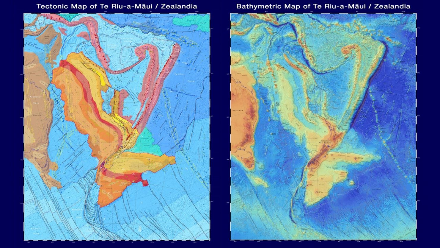
Now, maps reveal new research about the underwater continent where dinosaurs once roamed – and allow the public to virtually explore it.
GNS Science, a New Zealand research institute, published two new maps and an interactive website on Monday. The maps cover the shape of the ocean floor and Zealandia’s tectonic profile, which collectively help tell the story of the continent’s origins.
The maps also help explain the setting of New Zealand’s volcanoes, sedimentary basins, and other geological features, said GNS Science in a news release.
People around the world can explore the continent from their own homes; the interactive website shows different types of maps of Zealandia, which users can layer and toggle as they like. For instance, you could locate all the ancient and modern volcanoes on the continent, or see where on the land mass ridges are still spreading.
“These maps are a scientific benchmark – but they’re also more than that. They’re a way of communicating our work to our colleagues, stakeholders, educators and the public,” said geologist Dr. Nick Mortimer, the lead author of the maps, in the release.
“We’ve made these maps to provide an accurate, complete and up-to-date picture of the geology of the New Zealand and southwest Pacific area – better than we have had before.”
How the continent sank
The idea of a potential continent in this area has been around for some time, and the name “Zealandia” was first coined by geophysicist Bruce Luyendyk in 1995.
The dedicated study of this area, stretching about 5 million square kilometers (about 1.93 million square miles), has since determined it is not just a group of continental islands and fragments, but a continental crust large and separate enough to be officially declared a separate continent.
Zealandia used to be part of Gondwana, the supercontinent that once held many of the continents we know today, like Africa and South America.
About 85 million years ago, Zealandia split off from Gondwana. The drifting, shifting land mass, about half the size of Australia, was home to dinosaurs and lush rainforest.
Then, millions of years later, the world’s tectonic plates – pieces of the Earth’s crust – began reorganizing themselves, in a period of dramatic geological change that also created the Pacific “Ring of Fire,” a belt in the Pacific where the world’s most active volcanoes are located.
During this time, the Pacific Plate – the world’s largest tectonic plate – is believed to have sank below the continental crust of Zealandia. This process, called subduction, caused the root of the continent to break off and sink as well, according to the National Science Foundation, a US government research agency.
Abut 94% of Zealandia is now submerged underwater – but some parts of the continent are still above land, making up New Zealand and other small islands. The highest point of Zealandia is Aoraki–Mount Cook at 3,724 meters (12,218 feet).
There is still much unknown about the continent and whether the discovery of Zealandia could change historical climate models. As more research emerges, the interactive website and maps will be updated to reflect what we know, said GNS Science.