
The storm system that brought blizzard warnings to Southern California on Friday and Saturday will produce a significant damaging wind event across the central US on Sunday.
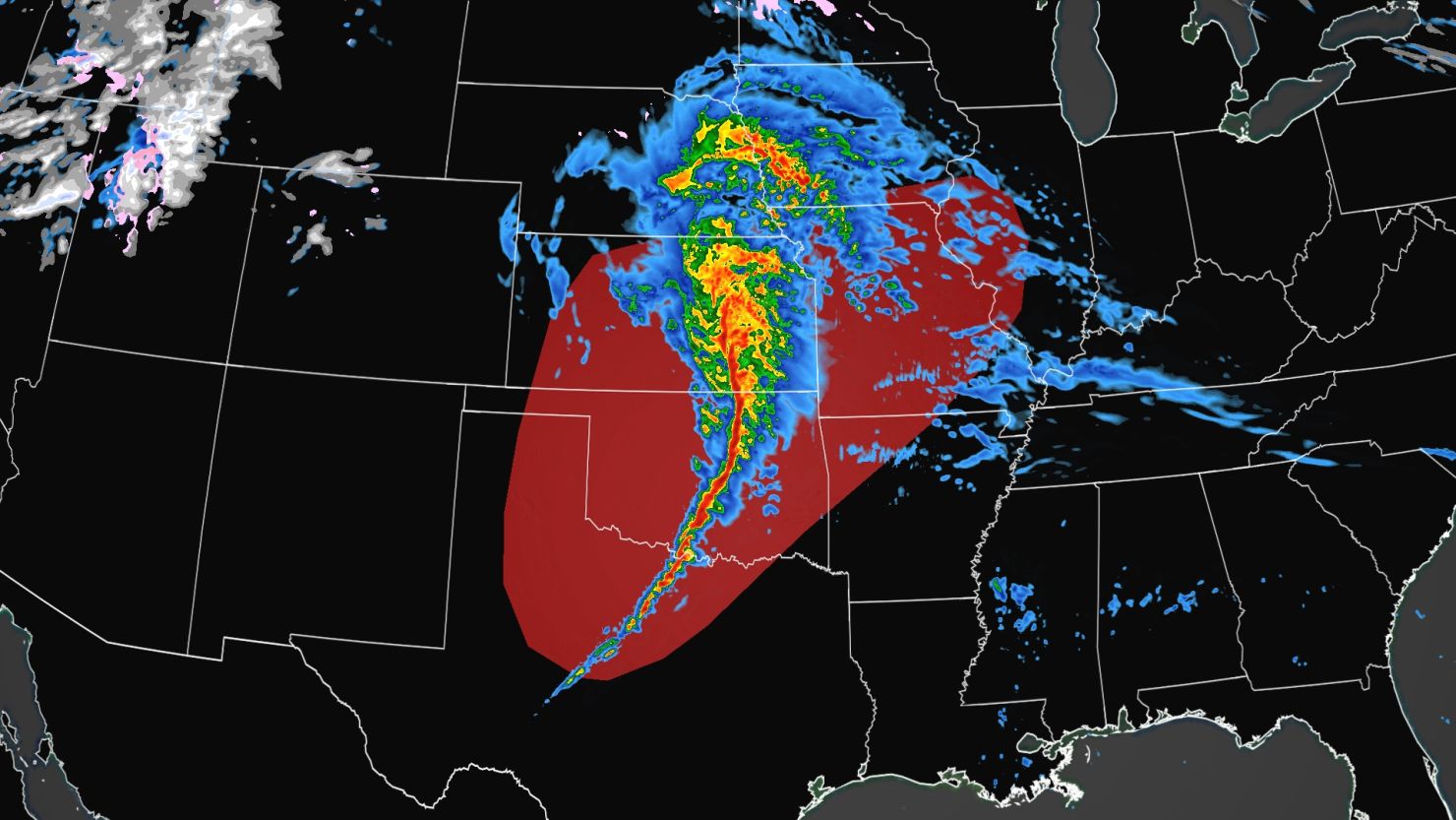
By midday Sunday the Storm Prediction Center was forecasting a derecho to develop Sunday afternoon and evening. A derecho is a widespread, long-lived, straight-line windstorm associated with a fast-moving group of severe thunderstorms.
“A derecho is forecast with widespread damaging winds and embedded swaths of significant severe gusts from 80-110 mph, centered on parts of Oklahoma this evening into tonight,” the storm center said. “Embedded tornadoes are anticipated as well, with the greatest potential for strong (EF2-EF3) tornadoes across southwest Oklahoma this evening.”
Winds of 80 to 110 mph are equivalent to a Category 2 Atlantic hurricane.
If a swath of damaging winds extends more than 240 miles and includes wind gusts of 58 mph or greater along most of its length, then the event may be classified as a derecho, according to the National Weather Service.
The highest severe storm risk today, a Level 4 out of 5 or moderate risk, has been issued across portions of western Oklahoma and Texas. Cities under this risk include Oklahoma City, Tulsa, Lawton, and Enid in Oklahoma. This area is where the highest chance of a strong tornado will be late Sunday afternoon.
This is the first Level 4 out of 5 risk issued so far this year, the last Level 4 risk was issued on December 14, 2022, when a tornado touched down in New Orleans.
Overall, more than 20 million people are under the threat of severe storms Sunday from western Texas to Illinois, including Oklahoma City, Tulsa, Kansas City, Fort Worth, and St. Louis.
“A significant damaging wind event is expected from the eastern Texas Panhandle into much of Oklahoma and southeast Kansas late this afternoon through this evening,” the Storm Predication Center wrote in their forecast discussion early Sunday morning.
Damaging wind gusts of more than 75 mph will be possible, as well as a couple strong tornadoes. Frequent lightning and hail are also possible.
The greatest tornado threat will be “early in the event” according to the storm center, meaning late this afternoon as storms track across portions of western-north Texas and southwestern Oklahoma.
This will then quickly transition into a damaging wind event this evening and into the overnight hours as the storms form into a squall line, which is a continuous and narrow band of thunderstorms that form ahead of a cold front.
“The storms will eventually evolve into a squall line,” the National Weather Service office in Norman, Oklahoma, said. Adding that embedded tornadoes within this squall line will still be possible as the storms track east.
The storms will also be moving rather quickly, racing east and northeast at 60 to 80 mph which will only add to the damaging wind threat.
“Damaging wind potential will not be confined to the thunderstorms themselves,” the Norman weather service office said. “Very strong winds and potentially damaging winds will be possible even in the general wind field after the storms move through.”
Wind alerts are currently in place for over 65 million people from Arizona to Ohio, including Albuquerque, Oklahoma City, Dallas, Memphis, Atlanta, St. Louis, and Cincinnati.
“Some models have been suggesting a narrow line of very strong winds moving through areas about three hours or so after the storms move through,” the weather service in Norman added.
Wind gusts of 60 to 75 mph are possible across the Southwest and western Texas behind these severe storms. And gusts of 40 to 55 mph are forecast across the central Plains through the Ohio River Valley.
By Monday morning, the threat of severe storms will shift to the north and east over the Ohio River Valley, where a Level 2 out of 5 risk has been issued. This includes Indianapolis, Cincinnati, and Louisville.
The main threats on Monday will be frequent lightning, damaging winds, hail, and a few tornadoes.
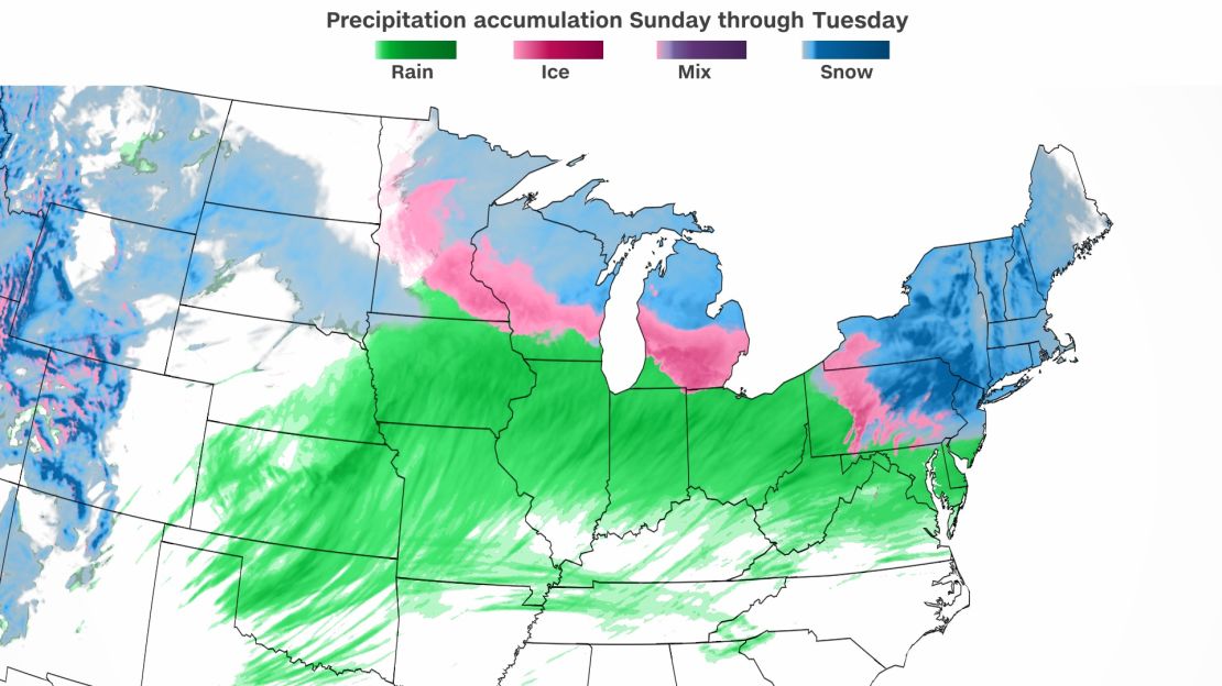
As this same system continues its trek eastward, it will bring the threat of heavy rain, snow, and ice to the Northeast and mid-Atlantic on Monday night which could lead to travel disruptions.
Snowfall totals of 6 to 12 inches are forecast for much of the Northeast, while light freezing rain is possible across northern portions of the mid-Atlantic.